Tourism GeographyUnit 213 min read
Physical Geography Fundamentals: Landforms, Climate Systems & Earth Processes
Unit 2 of Tourism Geography explores core physical geography concepts—landforms, climate systems, and Earth processes—that shape tourism destinations, from Himalayan peaks to coastal resorts, with real-world applications in Nepal’s travel industry.
TAKEAWAYS:
- Landforms (mountains, rivers, coasts) directly influence tourism infrastructure, accessibility, and visitor experiences (e.g., Everest trekking vs. Pokhara beaches).
- Climate systems (monsoons, temperature zones) dictate tourism seasons, risks (avalanches, floods), and sustainable practices (e.g., Darjeeling tea plantations vs. Thar desert tourism).
- Earth processes (plate tectonics, erosion) explain why some regions (e.g., Kathmandu Valley) are geologically active, affecting tourism safety and site selection.
- Physical geography intersects with human geography to create unique tourism products (e.g., Ncell’s "Himalayan Adventure" packages leveraging altitude zones).
- Maps and remote sensing tools (like Google Earth) help tourism planners analyze terrain, weather patterns, and resource availability for route planning.
- Sustainable tourism relies on understanding ecological limits (e.g., Chitwan National Park’s biodiversity constraints).
Core Concepts of Physical Geography
Physical geography studies Earth’s natural features and processes that shape landscapes, climates, and ecosystems—critical for tourism planning. Unlike human geography (which focuses on cultural/built environments), physical geography examines landforms, climate, soils, and hydrology, all of which directly impact tourism.
1. Landforms and Their Tourism Significance
Landforms are Earth’s surface features created by endogenous (internal) forces like tectonic activity and exogenous (external) forces like weathering/erosion. For tourism, they determine:
- Accessibility: Steep mountains (e.g., Annapurna Circuit) require permits and acclimatization, while flat plains (e.g., Tarai) allow easy travel.
- Attractions: Waterfalls (e.g., Pokhara’s Devghat), beaches (e.g., Bardia), and caves (e.g., Muktinath) are primary draws.
- Infrastructure: Coastal resorts (e.g., Lumbini) need flood-resistant designs; high-altitude hotels (e.g., Namche Bazaar) must handle thin air.
2. Climate Systems and Tourism
Climate—long-term weather patterns—dictates tourism seasons, risks, and experiences. Nepal’s climate varies by altitude and monsoon influence:
- Tropical (Tarai): Hot summers (40°C), monsoon rains (June–Sept). Tourism: Wildlife safaris (Chitwan), but flood risks.
- Temperate (Kathmandu Valley): Mild winters (5–15°C), dry seasons. Tourism: Cultural festivals (Dashain), hiking.
- Alpine (Pokhara): Cool summers (20–25°C), cold winters. Tourism: Paragliding, but limited winter access.
Worked Example: Monsoon Tourism in Nepal
- Impact: 80% of annual rainfall occurs June–September, flooding roads (e.g., 2017 Koshi flood disrupted Lumbini access).
- Adaptation: Tour operators like Nepal Trekking Agency offer "dry season" (Oct–May) packages to avoid landslides on trails like Annapurna Base Camp.
- Opportunity: Monsoon brings lush greenery, attracting photographers (e.g., rhododendron blooms in April–May).
3. Earth Processes: Tectonics and Erosion
A. Plate Tectonics and Tourism
Nepal sits on the Indian Plate colliding with the Eurasian Plate, creating:
- Himalayan uplift: Forms trekking destinations (e.g., Everest, Langtang) but also triggers earthquakes (e.g., 2015 Gorkha quake damaged heritage sites like Durbar Square).
- Rift valleys: Kathmandu Valley’s bowl shape (formed by faulting) creates a unique cultural hub but requires seismic-resistant tourism infrastructure.
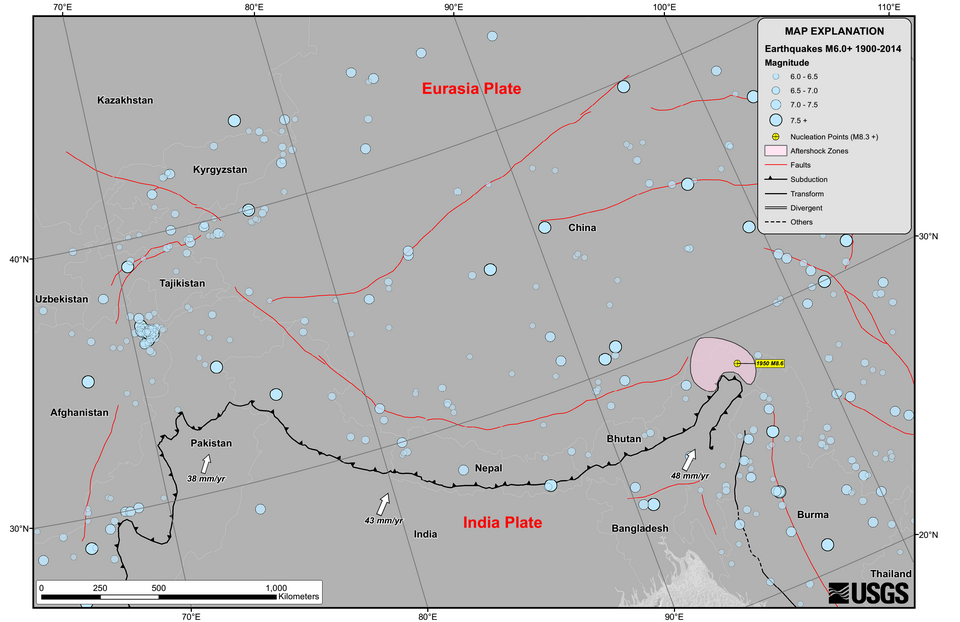 Shows Indian Plate subduction under Eurasia, forming the Himalayas. (Image: United States Geological Survey, Public domain, via Wikimedia Commons)
B. Erosion and Tourism Infrastructure
- Fluvial erosion (rivers like the Karnali) carves canyons (e.g., Bardia’s wild landscapes) but also causes riverbank erosion, threatening lodges.
- Glacial erosion shapes valleys (e.g., Langtang) but retreating glaciers (due to climate change) reduce water flow, affecting hydropower-based tourism (e.g., Pokhara’s adventure sports).
Worked Example: Pokhara’s Flood Risk Management
- Problem: The Seti River erodes banks near Lakeside, threatening hotels and restaurants.
- Solution: NTC (Nepal Tourism Council) collaborates with local governments to build revetments (rock barriers) and early warning systems for tourists.
flowchart TD
    A["River Erosion"] --> B["Bank Collapse"]
    B --> C["Hotel Damage\n(Lakeside, Pokhara)"]
    C --> D["Tourist Injuries"]
    D --> E["NTC Intervention"]
    E --> F["Revetments + Warnings"]
    F --> G["Sustainable Tourism"]
4. Soils and Vegetation in Tourism
- Soil types influence agriculture-based tourism:
- Alluvial soils (Tarai): Support tea plantations (Ilam) and rice terraces (tourism: farm stays).
- Mountainous soils (Himalayas): Thin, rocky soils limit farming but enable yaks and sherpa culture (tourism: Namche Bazaar).
- Vegetation zones (e.g., tropical forests in Chitwan vs. alpine meadows in Langtang) dictate wildlife and trekking routes.
5. Hydrology and Water Resources
- Rivers: Major transport routes (e.g., Karnali River for rafting) and power sources (e.g., West Seti Hydroelectric Project powers Pokhara’s tourism).
- Lakes: Rara Lake (tourism: boating) and Phewa Lake (Pokhara) are glacial-fed but face pollution risks from untreated sewage.
- Glaciers: Fed by Himalayan ice, they supply water for hydropower and agriculture, critical for tourism supply chains.
In the Real World
eSewa and Climate Data
- Idea Used: Climate zones and monsoon patterns
- How: eSewa’s "Tourism Package" app recommends trekking routes based on real-time weather forecasts (e.g., avoiding Langtang in monsoon). It uses IMD Nepal climate data to alert users about landslide-prone areas.
Pathao’s Route Optimization
- Idea Used: Landforms and accessibility
- How: Pathao’s ride-hailing algorithm adjusts fares and ETAs in Kathmandu based on terrain difficulty (e.g., steep Thamel roads vs. flat Lakshmi Path). It also avoids earthquake-prone zones post-2015.
Nepal Airlines’ Flight Scheduling
- Idea Used: Altitude and weather systems
- How: Flights to Lukla (Everest region) are delayed or canceled during pre-monsoon winds (April–May) due to turbulence. Pilots use metar reports (weather stations at Tribhuvan Airport) to plan safe altitudes.
Daraz’s Supply Chain in Tarai
- Idea Used: Flood risks and soil types
- How: Daraz warehouses in Birgunj (Tarai) use flood-resistant storage and alluvial soil-based drainage to prevent inventory loss during monsoons. They also stock waterproof goods (e.g., raincoats) as "monsoon essentials."
NTC’s Heritage Site Management
- Idea Used: Tectonic activity and erosion
- How: After the 2015 earthquake, NTC partnered with UNESCO to assess seismic vulnerability of sites like Swayambhunath. They now require flexible scaffolding for restoration to absorb tremors.
Exam Tip
Link Theory to Nepal’s Tourism:
- Always tie concepts to real destinations (e.g., "The Himalayas’ tectonic origin makes them a UNESCO site, attracting trekkers").
- Use NTC reports or World Bank data on climate risks (e.g., "80% of Nepal’s tourism revenue comes from the Himalayas, vulnerable to glacial retreat").
Diagrams = Marks:
- Sketch climate graphs, landform cross-sections, or tectonic plate diagrams in exams. Label them with tourism impacts (e.g., "Monsoon → Flooding → Road closures in Chitwan").
Case Study Approach:
- Questions often ask: "How does [concept] affect tourism in [place]?"
- Template:
"[Concept] in [place] creates [feature], which [positively/negatively] impacts tourism by [mechanism]. For example, [real example: e.g., 'the Koshi River’s erosion threatens Chitwan lodges, reducing safari bookings by 15% during monsoon']."
Avoid Generic Answers:
- ❌ "Climate affects tourism."
- ✅ "Nepal’s alpine climate limits winter tourism in Pokhara to paragliding, while the Tarai’s tropical climate enables year-round wildlife viewing but requires anti-malarial precautions."
Common Pitfalls:
- Don’t confuse weather (short-term) with climate (long-term). Example:
- ❌ "Last year’s snowfall in Langtang was bad for tourism." (Weather)
- ✅ "Langtang’s high-altitude climate (permanent snow) attracts mountaineers but requires acclimatization, increasing trek costs by 20%." (Climate)
- Don’t ignore human geography links. Example:
- ❌ "The Himalayas are tall." (Incomplete)
- ✅ "The Himalayas’ tectonic uplift creates high-altitude tourism (e.g., Everest Base Camp), but limited oxygen requires Sherpa guides, adding $50–$100/day to trek costs."
- Don’t confuse weather (short-term) with climate (long-term). Example:
Practice Question with Model Answer
Question: "Evaluate how physical geography influences tourism development in the Kathmandu Valley." Model Answer: The Kathmandu Valley’s physical geography—geological structure, climate, and hydrology—shapes its tourism uniquely through accessibility, risks, and attractions.
Tectonic Setting (Rift Valley):
- The valley sits in a fault-bound depression, creating a bowl-shaped basin that concentrates heritage sites (e.g., Durbar Square, Swayambhunath) but also makes it seismically active.
- Tourism Impact: The 2015 earthquake damaged 30% of heritage structures, reducing visitor numbers by 40% that year. NTC’s response: Mandated earthquake-resistant restoration (e.g., flexible joints in temples) to ensure UNESCO World Heritage status is retained.
Climate (Temperate with Monsoon Influence):
- Dry winters (Dec–Feb): Ideal for festivals (Dashain, Tihar), drawing 2 million domestic tourists annually.
- Monsoon (June–Sept): Heavy rains cause landslides on access roads (e.g., Nagarkot–Dhulikhel route), increasing travel time by 50%.
- Tourism Adaptation: Hotels like Hyatt Regency Kathmandu offer monsoon packages with indoor cultural experiences (e.g., Newari dance shows).
Hydrology (Lakes and Rivers):
- Lakes (e.g., Nagpond, Rani Pond): Serve as scenic spots for photography but face pollution from untreated wastewater, reducing aesthetic appeal.
- Rivers (e.g., Bagmati): Historically sacred but now clogged with plastic, deterring spiritual tourism. Solution: Nepal Tourism Board’s "Clean Valley" campaign partners with Pathao to organize litter-picking tours.
Soil and Vegetation:
- Terrace farming: Supports organic vegetable tourism (e.g., farms in Kageshwari-Manohara), but urban sprawl reduces agricultural land.
- Forests (e.g., Shivapuri Nagarjun National Park): Provide eco-tourism (bird-watching, trekking) but are threatened by illegal logging, reducing biodiversity.
Conclusion: The Kathmandu Valley’s physical geography offers unmatched cultural and natural attractions but requires seismic safety, climate-resilient infrastructure, and pollution control to sustain tourism. NTC’s integration of physical geography data (e.g., GIS mapping of earthquake zones) into tourism planning ensures long-term viability.
Key Terms to Memorize
| Term | Definition | Tourism Example |
|---|---|---|
| Endogenous forces | Internal Earth processes (e.g., tectonics, volcanism). | Himalayan formation → trekking routes. |
| Exogenous forces | External processes (e.g., weathering, erosion). | Karnali River erosion → Pokhara floods. |
| Monsoon climate | Seasonal wind pattern bringing heavy rain (June–Sept in Nepal). | Chitwan safaris canceled during peak rain. |
| Altitudinal zonation | Climate/vegetation changes with elevation. | Pokhara (temperate) vs. Tarai (tropical). |
| Fluvial erosion | River-driven landform changes. | Seti River erosion → Lakeside hotel risks. |
| Seismic activity | Earthquake risks due to plate tectonics. | 2015 quake → heritage site closures. |
| Alluvial soil | Fertile soil from river deposits. | Tarai tea plantations → farm tourism. |
Based on the TU BTTM syllabus for Tourism Geography (TTM303), unit 2.
Discussion
Loading…