Social Studies and Life SkillsUnit 511 min read
Nepal's Physical & Cultural Geography: Landscapes, People & Traditions
Unit 5 of Social Studies and Life Skills explores Nepal’s diverse physical features (mountains, rivers, climate) and rich cultural heritage (ethnicity, festivals, languages, traditions) through maps, data, and real-world examples—essential for NEB exams.
TAKEAWAYS:
- Nepal’s physical geography (Himalayas, Terai, hills) shapes climate, agriculture, and daily life.
- Cultural diversity includes 125+ castes/ethnicities, 123 languages, and unique festivals like Dashain and Tihar.
- Geographical regions (Mountain, Hill, Terai) differ in economy, lifestyle, and environmental challenges.
- Cultural geography links traditions (e.g., Newari architecture, Gurung festivals) to geography and history.
- NEB exam focus: Map-based questions, comparisons (e.g., Terai vs. Himalayas), and cultural significance of landmarks.
1. Nepal’s Physical Geography: A Land of Extremes
Nepal’s physical geography is as diverse as its people. From the world’s highest peak, Mount Everest (8,848 m), to the flat plains of the Terai, Nepal’s landscape is shaped by its location between the Himalayas and the Indian subcontinent. This diversity affects climate, agriculture, and how people live.
Key Physical Features
Nepal is divided into three main geographical regions, each with unique characteristics:
mindmap
root((Nepal's Physical Regions))
Mountain
"Himalayas (8000m+)"
"Cold climate, snow, glaciers"
"Limited agriculture (potatoes, barley)"
Hill
"Mid-hills (76m–4000m)"
"Moderate climate, forests"
"Agriculture (rice, maize, wheat)"
Terai
"Flat plains (70m–300m)"
"Hot, humid, fertile soil"
"Agriculture (rice, sugarcane, jute)"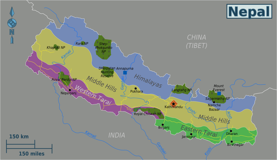 Nepal’s three main physical regions: Mountain, Hill, and Terai. (Image: Globe-trotter, CC BY-SA 4.0, via Wikimedia Commons)
How Geography Affects Daily Life
Mountain Region:
- Climate: Very cold, with snow for most of the year.
- Agriculture: Only hardy crops like potatoes, barley, and buckwheat grow.
- Occupations: People rely on herding (yak, sheep, goats) and tourism (trekking, mountaineering).
- Challenges: Limited roads, harsh weather, and difficulty accessing healthcare.
Hill Region:
- Climate: Moderate, with distinct seasons (hot summers, cold winters).
- Agriculture: Rice, maize, wheat, and vegetables are grown.
- Occupations: Farming, small businesses, and some tourism.
- Challenges: Landslides and soil erosion due to deforestation.
Terai Region:
- Climate: Hot and humid, with heavy rainfall in monsoons.
- Agriculture: Highly fertile soil supports rice, sugarcane, jute, and wheat.
- Occupations: Farming, industries (e.g., sugar mills), and trade.
- Challenges: Floods, waterlogging, and loss of wetlands.
Major Rivers and Their Importance
Nepal has six major river systems, which are vital for:
- Agriculture (irrigation).
- Hydroelectricity (e.g., Koshi, Gandaki, Karnali dams).
- Transportation (though limited due to terrain).
flowchart TD
  A["Himalayan Glaciers"] --> B["Rivers Originate"]
  B --> C["Koshi River"]
  B --> D["Gandaki River"]
  B --> E["Karnali River"]
  C --> F["Flows into India"]
  D --> G["Major Hydroelectric Projects"]
  E --> H["Supports Terai Agriculture"]
Climate Zones of Nepal
Nepal’s climate varies with altitude (height above sea level). The higher you go, the colder it gets. This is called a vertical climate zone.
| Altitude | Climate Zone | Temperature | Vegetation | Example Areas |
|---|---|---|---|---|
| Below 1,000 m | Tropical | Hot (25–40°C) | Sal forests, grasslands | Terai (e.g., Chitwan) |
| 1,000–2,000 m | Sub-tropical | Warm (15–30°C) | Pine, oak forests | Kathmandu Valley |
| 2,000–3,000 m | Temperate | Mild (5–20°C) | Oak, rhododendron forests | Pokhara, Dhulikhel |
| 3,000–4,000 m | Cold | Cool (0–15°C) | Pine, juniper forests | Nagarkot, Langtang |
| Above 4,000 m | Alpine | Very cold (<0°C) | Shrubs, mosses | Everest Base Camp |
2. Nepal’s Cultural Geography: A Tapestry of Diversity
Nepal is not just diverse physically but also culturally. It is home to 125+ castes/ethnic groups, 123 languages, and unique traditions that have evolved over centuries.
Ethnic and Linguistic Diversity
Nepal’s people can be broadly categorized into three groups:
Indo-Aryan (66%):
- Languages: Nepali, Maithili, Bhojpuri, Awadhi.
- Culture: Found mostly in the Terai and central hills.
- Example: Newars (Kathmandu Valley), Tharus (Terai).
Mongoloid (28%):
- Languages: Tibeto-Burman (e.g., Sherpa, Tamang, Gurung, Rai, Limbu).
- Culture: Found in the Himalayan and hill regions.
- Example: Sherpas (Everest region), Gurungs (Annapurna region).
Other (6%):
- Includes Muslims, Dalits, and other small ethnic groups.
Major Festivals and Their Significance
Festivals in Nepal are deeply tied to religion, agriculture, and seasons. Some of the most important ones are:
| Festival | Celebrated By | Time of Year | Significance | Unique Traditions |
|---|---|---|---|---|
| Dashain | Hindus | September–October | Victory of good over evil (Durga’s win) | Animal sacrifices, Tika ceremony |
| Tihar/Diwali | Hindus | October–November | Worship of Laxmi (goddess of wealth) | Oil lamps, cow puja, Bhai Tika |
| Losar | Tibetans (Sherpas, etc.) | February–March | Tibetan New Year | Butter lamps, prayers, feasts |
| Buddha Jayanti | Buddhists | April–May | Birth of Buddha | Processions, prayers, charity |
| Teej | Hindu women | September–October | Celebrates women’s happiness and marriage | Fasting, dancing, singing |
| Indra Jatra | Newars (Kathmandu) | September | Worship of Lord Indra (rain god) | Living god (Jwala) procession |
Architecture and Cultural Landmarks
Nepal’s architecture reflects its cultural diversity:
Newari Architecture (Kathmandu Valley):
- Features: Wooden windows, red brick, sloping roofs.
- Example: Pashupatinath Temple, Swayambhunath (Monkey Temple), Patan Durbar Square.
Tibetan-Style Monasteries (Himalayan Region):
- Features: Stupas, prayer wheels, colorful murals.
- Example: Boudhanath Stupa, Swayambhunath, Lumbini.
Tharu and Terai Houses:
- Features: Thatched roofs, open courtyards.
- Example: Traditional Tharu houses in Chitwan.
Cultural Practices and Traditions
- Wedding Ceremonies:
- Hindu: Jaimaliko (bride’s family gifts groom), Sagai (engagement).
- Buddhist: Lhakpa (Tibetan-style ceremonies).
- Funeral Rites:
- Hindus: Sky burial (in some Himalayan regions) or cremation.
- Buddhists: Sky burial or cremation.
- Music and Dance:
- Newari: Dewa Dance (masked dance).
- Gurung: Chyangra Dance.
- Magar: Maruni Dance.
3. How Physical and Cultural Geography Are Linked
Nepal’s physical geography shapes its culture, and vice versa. Here’s how:
| Physical Feature | Cultural Impact |
|---|---|
| Himalayan Region | Sherpas, Gurungs, and other Himalayan groups follow Buddhist traditions and rely on yaks for transport. |
| Hill Region | Newars, Tamangs, and Magars have unique festivals (e.g., Indra Jatra) and agriculture-based economies. |
| Terai Region | Tharus and other groups practice animism and have distinctive thatched houses. |
| Rivers and Forests | Many festivals (e.g., Gai Jatra) involve animal worship and forest-based rituals. |
4. Exam Tips for NEB Social Studies (Unit 5)
The NEB exam tests your understanding of maps, comparisons, and cultural significance. Here’s how to score full marks:
What to Expect in the Exam
Map-Based Questions:
- You may be asked to label regions (Mountain, Hill, Terai) or mark rivers/festivals on a blank map.
- Tip: Memorize the three regions and major rivers (Koshi, Gandaki, Karnali).
Comparison Questions:
- Example: "Compare the climate and agriculture of the Terai and Mountain regions."
- Tip: Use a table (like the one above) to organize your answer.
Cultural Significance:
- Example: "Why is Dashain important to Nepalis?"
- Tip: Explain religious, social, and economic aspects (e.g., family reunions, business openings).
Short Answer Questions:
- Example: "Name two ethnic groups in the Himalayan region and their occupations."
- Tip: Give specific examples (e.g., Sherpas = mountaineering guides).
Common Mistakes to Avoid
- Mixing up regions: Don’t confuse the Terai (flat) with the Hills (moderate).
- Ignoring cultural details: Festivals like Losar are celebrated by Tibetan groups, not all Nepalis.
- Poor map skills: Practice labeling maps regularly.
Sample NEB-Style Questions & Answers
Question 1 (Map-Based): "Label the following on the given map of Nepal: (a) Koshi River, (b) Terai Region, (c) Annapurna Mountain Range."
Answer:
flowchart TD
  A["Nepal Map"] --> B["Koshi River: Eastern Nepal"]
  A --> C["Terai Region: Southern Flatlands"]
  A --> D["Annapurna: Central Himalayas"]
Question 2 (Comparison): "Compare the climate and agriculture of the Mountain and Terai regions of Nepal."
| Aspect | Mountain Region | Terai Region |
|---|---|---|
| Climate | Very cold, snow-covered, short growing season | Hot, humid, long growing season |
| Agriculture | Potatoes, barley, buckwheat (limited crops) | Rice, sugarcane, wheat (high yield) |
| Occupations | Herding (yaks), tourism | Farming, industries, trade |
Question 3 (Cultural Significance): "Explain the importance of Dashain in Nepali culture."
Answer: Dashain is Nepal’s longest and most important Hindu festival, celebrated for 15 days in September–October. Its significance includes:
- Religious: Celebrates the victory of Goddess Durga over the demon Mahishasura, symbolizing good over evil.
- Social: Families reunite, and elders give Tika (blessings) to younger members.
- Economic: Businesses reopen after the monsoon, and animal sacrifices boost local markets.
- Cultural: Jamara (sprouted barley) is worshipped, and public holidays strengthen community bonds.
5. Quick Revision Checklist
Before the exam, revise these key points: ✅ Three geographical regions: Mountain, Hill, Terai (climate, crops, occupations). ✅ Major rivers: Koshi, Gandaki, Karnali (importance for agriculture and hydroelectricity). ✅ Ethnic groups: Indo-Aryan (Newars, Tharus), Mongoloid (Sherpas, Gurungs). ✅ Major festivals: Dashain, Tihar, Losar, Buddha Jayanti (who celebrates, why, traditions). ✅ Architecture: Newari (wooden windows), Tibetan (stupas), Tharu (thatched roofs). ✅ Exam tips: Maps, comparisons, cultural significance.
Final Note: Nepal’s physical and cultural geography are deeply connected. Understanding this link will help you score well in NEB exams and appreciate your country’s diversity! 🇳🇵✨
Based on the NEB +2 Management syllabus for Social Studies and Life Skills (SSLS), unit 5.
Discussion
Loading…